- About the project
- Object of research
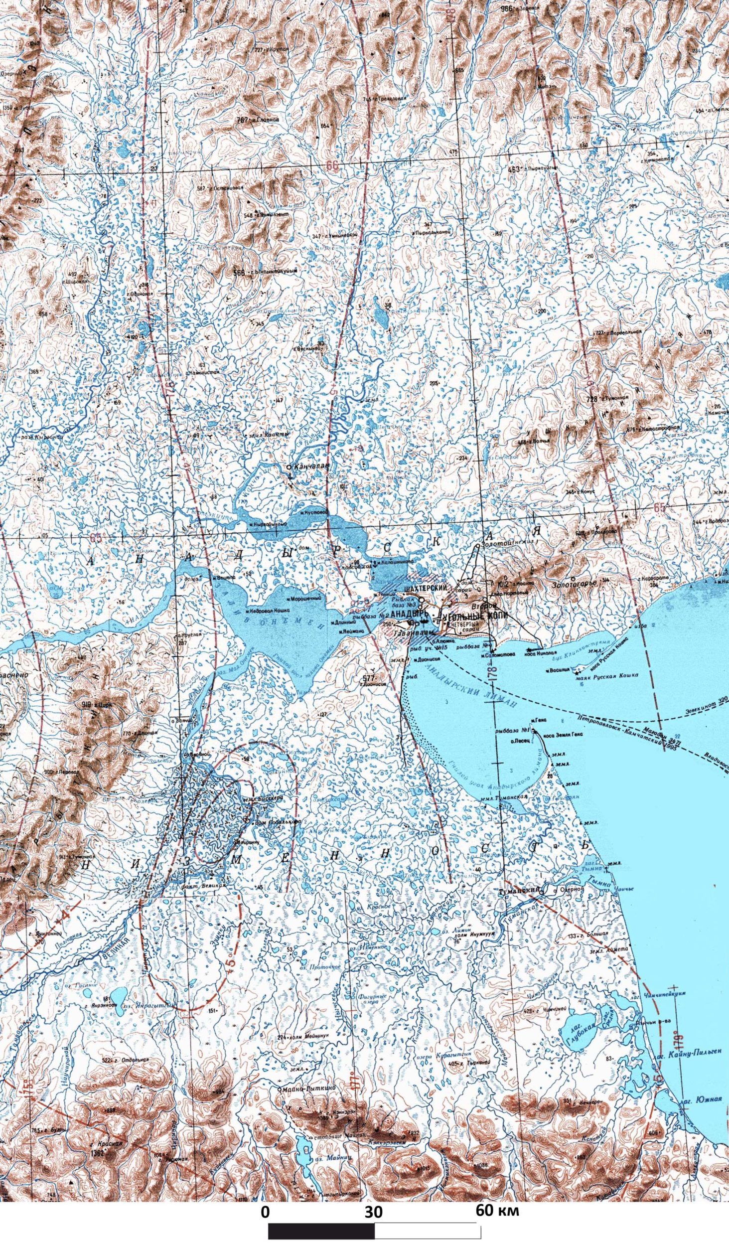
- Chukotka Autonomous Okrug
- The Republic of SAKHA (Yakutia)
- Magadan region*
- Method of research
- Permafrost research
- Hydrology and hydrometry*
- Water balance calculations*
- Geophysical survey*
- Landscape research*
- Observational data
- Anadyrsky district of Chukotka*
- Chaunsky district of Chukotka*
- The Republic of SAKHA (Yakutia)*
- Magadan region*
- Research result
- 2018-2019*
- 2019-2020*
- 2020-2021*
- Maps and photos
- The Anadyr lowland
- Chaunskaya lowland
- Lena basin
- Northern Priokhotye*
- Contacts
- Project participant
* — page under construction
Object of research
Chukotka Autonomous Okrug
The objects of research in the Chukotka Autonomous district are the Anadyr and Chaun lowlands.
THE ANADYR LOWLAND
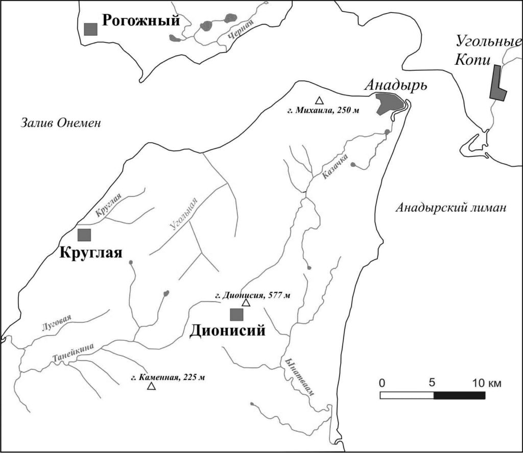
he objects of research are the catchment basins of the Ugolnaya-Dionisius и Kruglaya rivers, monitoring sites for the seasonal thaw layer CALM (Circumpolar Active Layer Monitoring: Long-Term Observations of the Climate-Active Layer-Permafrost System) «Cape Rogozhny», «mount Dionisia», «Kruglaya».
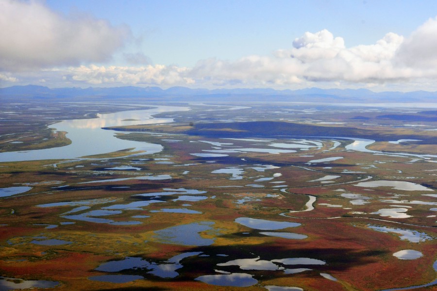
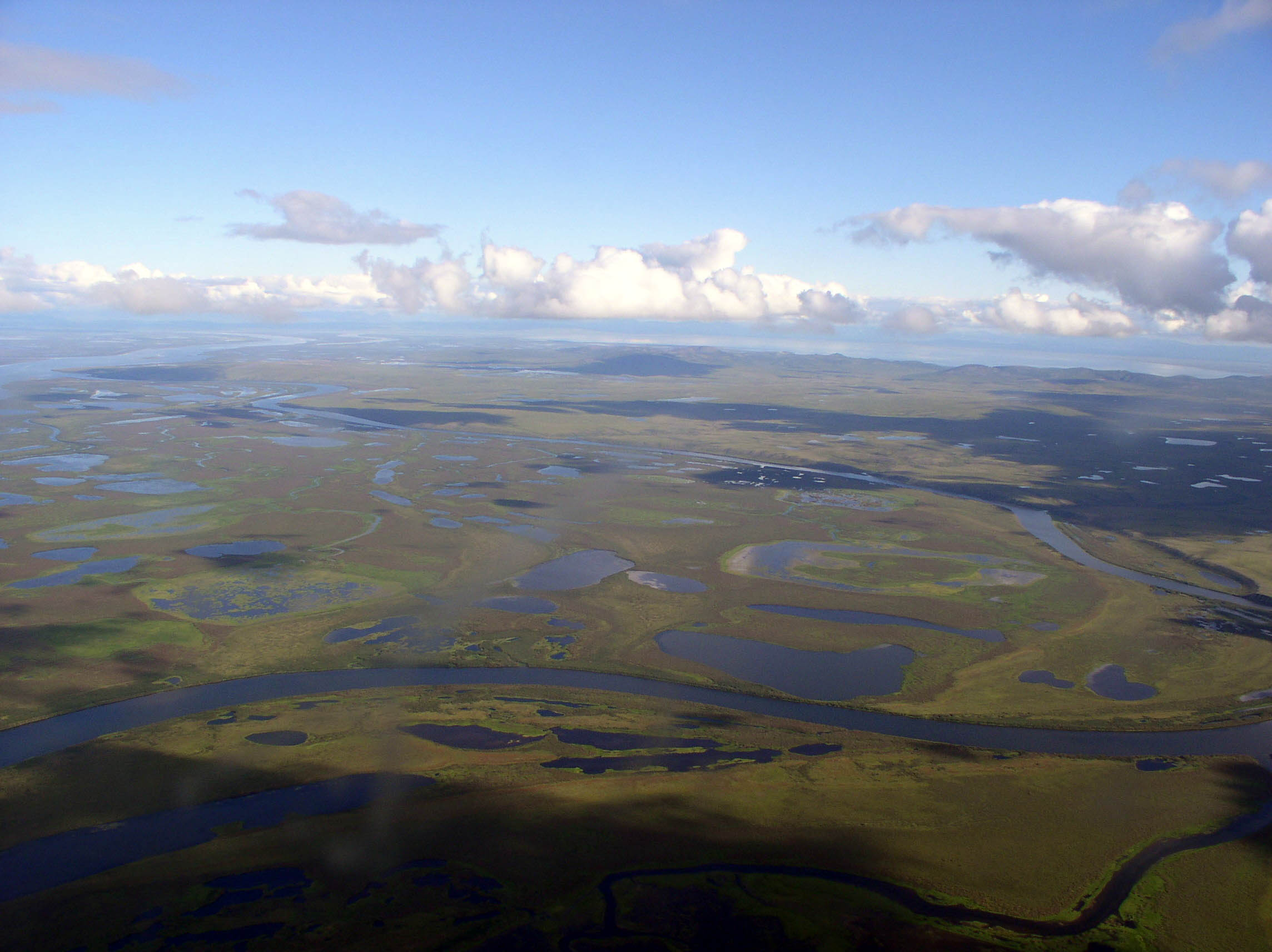
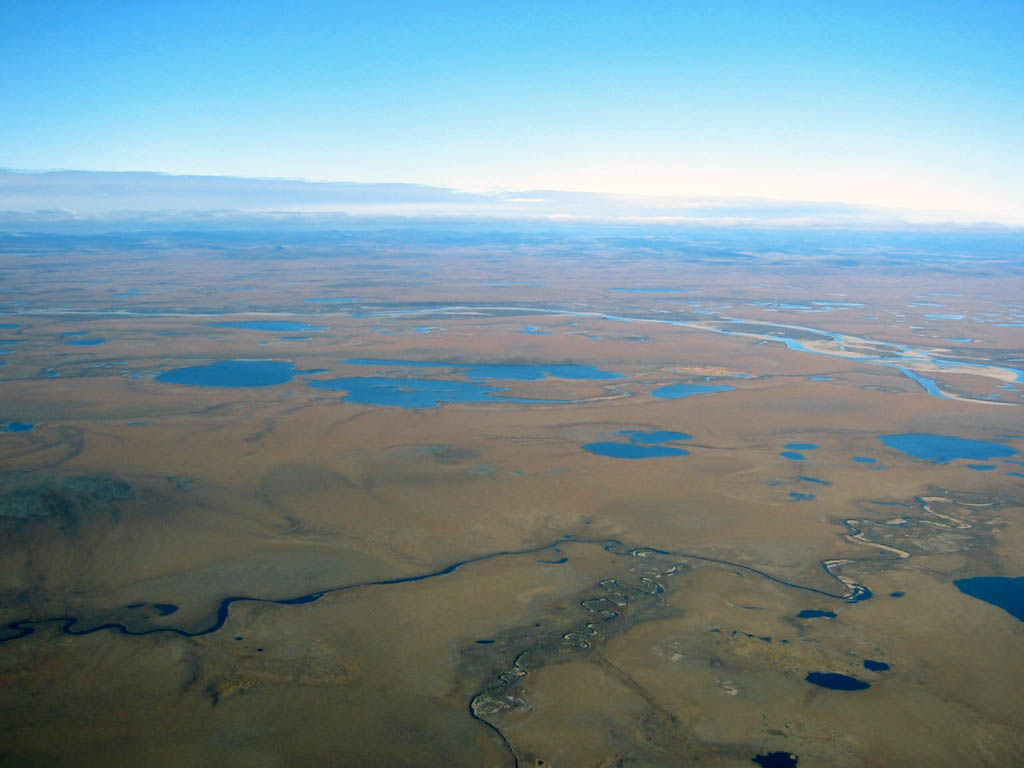
The Anadyr lowland covers an area of about 35 thousand and is located in the North-East of Asia in the Chukotka Autonomous region of the Russian Federation. The lowland surrounds the Anadyr estuary and is open to the South-East to the Bay of the same name in the Bering sea. From the West it is limited by the range Pekulney, North Konchalovskie mountains, to the East by the range Finder and the mountains Ushkanyi, of the southern Koryak highlands. In the Central part, the Anadyr lowland is divided into the Northern and southern halves of the Rarytkin ridge, the Golden one, and small mountain ridges 200-500 m high.
The Anadyr lowland is located on the borders of the marine and temperate continental subarctic climate:
| Average annual air temperature, °C | Average winter temperature for the period X-VI | Average summer temperature for the period V-IX | Average rainfall, mm | Date of snow cover formation | Duration of a period a temperature above 0 | Mean wind speed |
|---|---|---|---|---|---|---|
| -7,7 | -15,2 | 312 | 17/Х | 128 | 6,7 |

Climate conditions are formed under the influence of Pacific, Arctic and Central Asian cyclones and anticyclones. This results in frequent weather changes and short-period fluctuations in climate indicators.
The Anadyr lowland is a mostly treeless, swampy hilly tundra with elevation marks from 2 to 60-100 m. On landscape maps, the lowland is located within the boundaries of southern shrub tundras, called olhotundras because of the limited distribution of cedar forest. The vegetation cover is dominated by typical hummocky-shrubby-Moss-downy polygonal tundras with flat watersheds and gentle slopes, bumpy Moss-sedge runoff strips with low-growing willows, and tundra-cleft lake basins. Less common are shrubby lichen-moss and mixed-grass tundras of drained slopes and watersheds. In floodplains of rivers and streams, Moss-sedge and grass-grass willows and alders are common.

Numerous thermokarst lakes connected by channels and windings of rivers form a peculiar pattern of the wetland hydrosystem. The area of the lowland is divided by the catchments of the lower reaches of the major rivers of the region-Anadyr, Tanyurer, Kanchalan, Tumanskaya and Velikaya. Medium-sized (Autotkul, third river, Tavaivaam, Volchya) and numerous small rivers flow directly into the Anadyr and Kanchalansky estuaries in terms of catchment area and Flow. The average annual flow from the territory of the Anadyr lowland is estimated at 9.5 l / seс×km sq. 99 % of it was provided by atmospheric precipitation, the average annual amount of which for the years 1996-2016 was: solid precipitation-250 mm (38% variation), liquid precipitation-140 mm (17% variation).
At the same time, interannual changes in the amount of precipitation during this period reached: winter precipitation-210 mm, summer precipitation-250 mm.
Permafrost rocks with a capacity of 100 to 250 m have a continuous distribution on the territory. Only in the South, in the foothills of the Koryak highlands, with the thickness of frozen rocks thinning to 80-50 m, the solid permafrost is replaced by an intermittent one. Through talic zones are confined to the beds of large rivers, rarely to deep faults drained by small rivers and streams. A significant spread in the Anadyr lowlands have the supra permafrost lacustrine taliks power in the first tens of meters. The temperature of permafrost varies from South to North from -1.4 to -7.5 °C. Underground ice is mainly represented by wedge ice, segregation ice, and ice ground of the transition and intermediate layers. In the structure of the seasonally thawed layer, with a capacity of 45 to 75 cm, several layers are allocated-horizons that differ in structure and composition, freezing and thawing conditions. The upper part of the section forms an annual thawing soil profile (45-55 cm). There is an icy transition layer (10-20 cm) under the soil that thaws periodically during warm and rainy years, as well as under the influence of tundra fires.
River Ugolnaya-Dionysius
The Ugolnaya -Dionysius river got its name due to the outlets in the sides of the lower flow of coal layers and the right source in the North-Western spurs of mount Dionysius. The double name was required because of the need to distinguish it from other small rivers in the region with the name — Ugolnaya. The length of the river 24 km. The main tributaries (3rd order): The Right (5.6 km) and Left (7.5 km) Dionysius, Ezdovaya (7.5 km) with a tributary of the Yagodny stream (8.8 km). The height of the water’s edge ranges from 100 and 180 m at the source, to 2.5 m at the mouth, which is located on the right Bank of the Anadyr gorl. The width of the riverbed, winding in the lower course, reaches 14 m, the depth of fording — 0.6 m. The river valley has a V-shape with a steeply steep left side. The width of the floodplain in the upper сourse is 20-30 m, in the lower reaches up to 60 m. The above-floodplain terrace is fragmentary.
Along the perimeter of the catchment area with an area of 96 km sq., there are hills with elevations of 250-150 m (Sharp, Large and Small, Round). Within the catchment area, there are extensive and extended slopes with a length of 2 to 7 km and a slope of 0.75 to 3.5°. The sources of streams and slope terraces are often swampy. On the right side of the river, in the interstitial area of the river Sledova-Light stream on the intra-basin watershed with a height of 59.8 m, there are Goose lakes with a total area of about 0.6 km sq. The vegetation cover of the territory is tundra, typical for the Anadyr lowland. In the upper reaches of streams on steep slopes there are alders park, in the floodplain of rivers and streams, willow thickets.
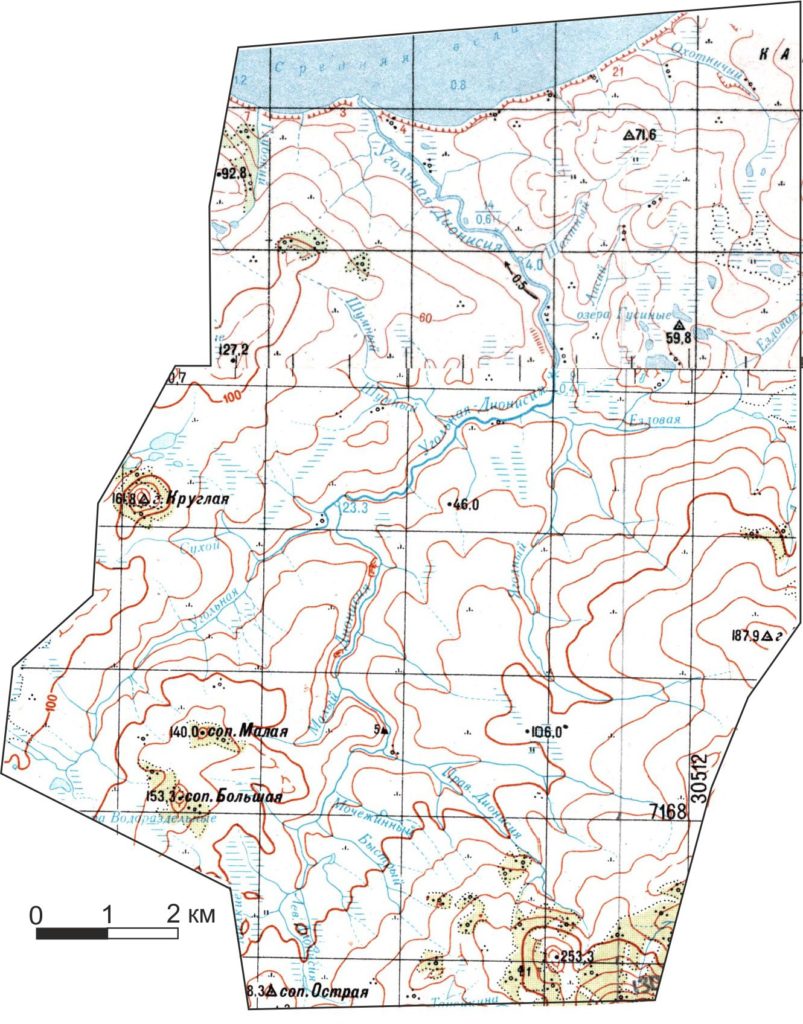
The River Kruglaya
The Round river owes its name to the round-shaped hill of the same name, which is located at its source. The 8 km long river flows into The Onemen Bay and has two tributaries: the stream Olha (3.8 km) and a stream Ozerny (5 km). The source of the river, as well as the source of the Ozerny tributary, falls on the group of thermokarst Senakos lakes (0.24 km sq). The river basin with a catchment area of 23.8 km sq. is covered by a hilly tundra with elevations ranging from 120 m in the upper reaches to 30 m in the lower reaches and a relative excess of 60 to 25 m. Within the catchment area, typical hummocks are common on sea terraces and slopes with a steepness of 1-3°, upper and low-lying tundras are common on flattened watersheds in the upper reaches of streams and in the lake-marsh basin. The valley of the river and its main tributaries in the upper reaches and at the mouth is flattened, and in the middle reaches has a V-shape. The riverbed meanders at the exit to the mouth of the lake-Marsh basin. There is a floodplain and a fragmentary low above-floodplain terrace composed of sand and clay deposits. In the valve of the river 850 m above the mouth in the summer low water of 2011, it was determined that the width of the water stream of the riverbed is 2.8 m; the depth is 0.25 m; the speed is 0.4 m / s, which allowed us to estimate at that time the flow from the basin of 9.8 l / sec*km sq.
The site «Cape Rogozhny»
The site «Cape Rogozhny» is located on the Northern shore сreek of the Onemen, 400 m North-West of cape Glubokiy (old names: Small eared seal cat, Rogozhny). Complex landscape-permafrost studies were started here in 1989 (A. N. Kotov, S. N. Brazhnik) and continued in 1993 with the creation of the Onemen ecological site. For the first time cryolithological sections of thermoabrasion cliff were described by B. I. Vtyurin and sh. sh. Hasanov in 1960. The site has started system observations of the temperature and capacity of the seasonally thawed layer and the activity of cryogenic processes in the framework of the CALM program since 1994.
The site is 100×100 m in size and is located on the flattened top of the tundra ridge with gentle slopes and absolute elevation marks of 18-20 m. within the site, the projective coverage of shrubs is 30-40%, green mosses-20-30% and bushy lichens-5-10%. The main producer of superficial phytomass is pushitsa (up to 60% of the projective coating).
Soils within the site are peat-gley (gleesemes) with a low-power (up to 10-20 cm) organogenic horizon, underlain by peaty sandy loams. Below are fine-grained sands of late Pleistocene age with a capacity of up to 20 m, which are underlain by glacial boulder loams of middle Pleistocene age. The CALM site is located in the area of continuous distribution of MMP. Talik zones of hydrogenic origin in this area are observed only under the water area of the Onemen creek and large lakes. The average annual temperature of permafrost rocks is about -5°C, the permafrost rocks capacity reaches 150 m. From cryogenic processes within the site, frost splitting and formation of wedge ice, as well as the formation of loamy spots-medallions. In the adjacent area, coastal processes are widespread: thermal abrasion and the formation of thermokarst cirque on massive ice bed. The cryolithological structure of the MMP is very diverse. Immediately below the seasonally thawed layer modern and Holocene wedge ice up to 2 m wide and up to 3 m high. Syngenetic wedge ice up to 2 m wide and up to 20 m long is traced vertically in fine-grained sands of late Pleistocene age. Hydrochemical conditions of the site are largely determined by the proximity of the sea coast. The type of precipitation here is transitional from Marine to continental. Rain and meltwater are sodium chloride-bicarbonate waters with a mineralization of up to 45 mg / l. The seasonally thawed layer receives meltwater and rainwater, which are saturated with calcium, magnesium and bicarbonate ions, and the mineralization increases to 80-88 mg / l. the measured mineralization of surface water in wells was 25-40 mg / l, pH 5.5-6.
Annual observations at the site include measurements in September with a metal probe of the depth of seasonal thawing on the network of 10×10 m (121 points) and year-round recording of the temperature of soil horizons (25, 35, 45 cm) at intervals of 4 hours. Temperature monitoring is performed using ONSET HOBO devices (U23-003 and others). The average depth of seasonal thawing varies between 42-58 cm.
Site «Mount Dionysius
The 100×100 m mount Dionysius platform is located on the South-Eastern slopes of the mountain of the same name, 577 m high, at its foot. The site occupies a flat slightly convex section of the slope in the range of absolute height of 145-150 m, with a relief slope of 1-4°. The typical tundra gley soils are predominant peaty and peaty-humus. According to the results of drilling at a depth of 0.5-0.6 m, the soil profile is replaced by highly icy sandy loams or loams of the transition layer, and then at a depth of 0.8-1 m, slope sandy loam gravelly deposits. The vegetation cover is heterogeneous, it is a combination of Moss-shrub patches, grassy lawns and surface runoff strips (grassy rivers, runoff hollows), usually swampy, overgrown with cotton-grass. Spot-Medallions lare widely represented on the site, forming groupings along the runoff lanes. low peat sands measuring 0, 4x1x2 m are common within the zakochkarennoy part of the site. Low – growth willow species are typical for runoff bands, and dwarf willows are typical for areas of bumpy and hummocky tundra. On the convex section of the slope that restricts the flow bands, a growth of shrubby alder is fixed. In General, the share of runoff strips accounts for 17 % of the area, wetlands occupy 23 % of the territory. The remaining area — 60% — is occupied by undivided hummocky and bumpy tundras. The measured surface water mineralization within the site varied from 8 to 35 mg / l, with a pH of 6.4. The site is located in the headwaters of the river Taneika, tributary Second River. Annual observations on the site began in 1996, which include measurements of the depth of seasonal thawing on a network of 10×10 m (121 points)in September with a metal probe and year-round recording of the temperature of soil horizons (25, 35, 45 cm) at intervals of 4 hours. Temperature control is carried out using HOBO devices (U23-003, etc.). The average depth of seasonal thawing is in the range of 45-67 cm.
Annual observations on the site began in 1996, which include measurements of the depth of seasonal thawing on a network of 10×10 m (121 points)in September with a metal probe and year-round recording of the temperature of soil horizons (25, 35, 45 cm) at intervals of 4 hours. Temperature control is carried out using HOBO devices (U23-003, etc.). The average depth of seasonal thawing is in the range of 45-67 cm.

Site «Kruglaya
The «Kruglaya» 100x100m site is located in the lower reaches of the Kruglaya river (500 m from the mouth), Onemen on the southern shore of the Bay, in its southern part called the Rotten corner of The onemen Bay. The site is located in a lake-swampy basin of thermoabrasion and thermokarst Genesis. The basin has the shape of a horseshoe, open to the sea, the size of 750×1100 m, surrounded by a hollow top with ridge absolute height of 15-20 m and exceeding the bottom to 17 m. The Bottom of the basin is flat, almost half of it is occupied by large and small thermokarst lakes. The height of the coastal scarps of the lakes does not exceed 1 m, the cut-in of the riverbed into the bottom of the basin reaches 1.5 m. The chemical composition of the lakes is divided into hydraulically connected to the sea and isolated. The composition of the waters of the first lakes is hydrocarbonate-chloride-sodium, mineralization 1.6 g / l, pH 7.2. The waters of isolated lakes are chloride-hydrocarbonate-calcium, rich in organic matter, with a mineralization of 146 mg / l, pH-7. Surface water mineralization within the site is 80-460 mg / l, pH-5.5-7.
Tundra soils are gleyish hydro-peat, peat, peaty, and are covered with silty, strong ice sandy loams. The vegetation cover of the site is heterogeneous. Most of it is occupied by hummocky-bumpy shrub-moss-sedge tundras. Bumpy moss-shrub tundras are common on the southern and northern periphery. The bumpy terrain is leveled to the North of the center , the degree of moisture increases, and sphagnum-sedge vegetation is distributed. The extreme Eastern part of the site is occupied by shrub-moss-sedge vegetation, with a growth of willow, single alder, up to 1 m high. A banks-polygonal relief is fixed in the central and South-Western part of the site. The length of the polygon side is 16-20 m.
Annual observations at the site began in 1996. Observations included measurements with a metal probe of the depth of seasonal thawing on a network of 10×10 m (121 points) and year-round registration of the temperature of soil horizons (25, 35, 45 cm) with an interval of 4 hours in September. Temperature monitoring is performed using start devices HOBO ONSET (U23-003 and others). The average depth of seasonal thawing varies between 43-48 cm.
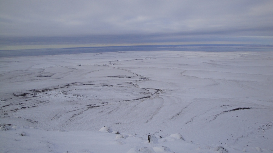
CHAUNSKAYA LOWLAND

The Chaunskaya lowland is surrounded by the ridges of the Anyuisk-Chukotka mountain region and is open through the Chaunskaya Bay to the East Siberian sea. The area of the lowland is about 20 thousand km. In General, it is a flat lake-alluvial plain of the Delta region of rivers fluenting from the Anadyr upland, Anyuysk and Chukotka highlands. On detailed examination, three geomorphological zones can be identified within the lowlands. The Southern, Delta, and Northern (Kargin and Aion Islands) zones. Waterlogged and wetlands with a terrain height of 10-50 m on Neogene-Quaternary continental and marine sediments. Weakly dislocated cretaceous sedimentary and volcanic rocks form a low plateau with relief marks of 100-300m on the Eastern coast of the gulf of Chaunskaya Bay. The Western coast of the Chaunsky Bay is bordered by the foothill (HR. Shelagsky), a ridgy plain inclined to the sea with a terrain height of 50-100 m, composed of Jurassic sandstones and siltstones. Within these zones, single mountains are common, confined to isolated Intrusive massifs with a height of 600 to 1000 m.
The climate is Arctic marine. The radiation balance is negative. In cold weather, the Taimyr and Yakut anticyclones dominate, causing the predominance of Western and North-Western winds, which periodically change to warm southern ones at a speed of up to 30 m / s. Strong winds cause snow redistribution. In the summer, cyclonic activity prevails, with moderate North-easterly and easterly winds, sometimes alternating with southerly, strong and warm winds. Frequent fogs, drizzling rains, relative humidity up to 84 %. The repeatability of dull skies is 65-70 %. Low evaporation of moisture causes a high coefficient of humidification of the area. Low evaporation of moisture causes a high coefficient of humidification of the area. Below are some climate indicators from the Pevek polar station and the Chaun weather station.
| Meteorological station | Average annual air temperature, °C | Average winter temperature for the period X-VI | Average summer temperature for the period V-IX | Average rainfall, mm | Date of snow cover formation | Duration of a period a temperature above 0 | Mean wind speed |
|---|---|---|---|---|---|---|---|
| Pevek | -10,6 | -15,5 | 5,1 | 214 | 5/X | 118 | 4,5 |
| Chaun | -12,8 | -22,0 | 5,6 | 251 | 28/IX | 111 | 4,6 |
Permafrost rocks (MMP) have a continuous distribution. The capacity of the permafrost of the lowland varies depending on the terrain within 100-200 m (230 m — Pevek). Under the water area of the Chaunsky Bay, the power of the MMP with a distance from the coastline decreases to 50-20 m. In General, the section of the MMP has a complex tiered structure in which thicknesses (50-100 m) of cooled rocks (-2 — (-4) °C) with cryopegs (up to 110 g/l) take part. The temperature on the sole of the layer of seasonal temperature fluctuations is -5 — (-7) °C (-6, Pevek). Talik zones with a capacity of 20-30, up to 50 m are confined to large non-freezing lakes and riverbeds in the middle and lower reaches.
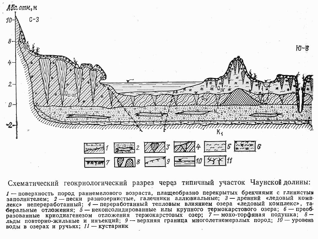
1-the surface of the rock of early сretaceous age, massively covered with breccias with clay aggregate; 2- mixed-grained Sands, alluvial bench gravel; 3-the ancient «ice complex» of crude; 4-processed by the thermal influence of the lake «ice complex», taberal deposits; 5-unconsolidated muds of large thermokarst lake; 6-converted criodiagenesis sediments of thermokarst lakes; 7-moss-peat pillow; 8-wedge ice and injection ice; 9-upper boundary of permafrost rocks;10-water level in lakes and streams; 11-shrubberies
Open talik hydrogeneous type are single (lake Holodnoe). The depth of seasonal thawing is 30-40 cm. When the power of the soil and vegetation cover is reduced, it increases by 1.5-2 times. Seasonal thawing of open slopes composed of fractured bedrock can reach 2-2. 5 m. Within the Chaunsky lowland and its mountain frame, ice complexes of syngenetic and epigenetic repeatedly-wedge ice are widespread confined to alluvial, lake, marsh, deluvial-solifluxion deposits. The ice content of dispersed deposits often exceeds 50-60%. For fractured crusts of weathering sedimentary rocks, goletz ice is typical. Within the lowlands, permafrost heaving is widely developed with the formation of numerous boolgoonnyakhs from 3 to 10 m of relative height.
On the Chaunskaya lowland accounts for the lower reaches of long rivers with large catchment: Palawaam (415 km, 12.9 thousand), Chaun (205 km, 23 ), Pucheveem (249 km, of 4.9 km sq), Lelyuveem (203 km, to 4.54 km sq), Ichuveem (km 154, 3 km sq), Mlelyuveem (133 km, 2.7 thousand km2). The lower course of these rivers forms a swampy lowland on the South-Western Bank of the Chaunsky Bay, which is characterized by numerous arms and channels, oxbow-lake, and thermokarst lakes. The lower course of these rivers forms a swampy lowland on the South-Western Bank of the Chaunsky Bay, which is characterized by numerous arms and channels, oxbow-lake, and thermokarst lakes. On the Eastern and Western banks of the Chaunskaya Bay, the drainage system is more sparse and formed by 3-4-order watercourses with a length of 10-20 km. On the North-West coast of the Bay in the middle and lower reaches river-bed of the small rivers Apapelgyn and Yergyveem pass through a vast, no less swampy than in the South of the lowlands, but with fewer thermokarst lakes. In General, most lowland rivers that have their origins in mountainous areas in the lower reaches are characterized by a wide shingle shallow bed, with Ford crossings 15-35 m wide, 0.5-1 m deep. The estuaries of the rivers on the contrary are deep, subject to tidal influence and wind piling up of water, and have a liman appearance. The flow modulus of the catchment basins of rivers flowing into the Chaunsky Bay does not exceed 6-7 l/s per km sq. Nutrition is snow, the main flow is during high water in the summer. Melting snow flakes and extensive icening take part in feeding the rivers. In addition to winter, in anticipation of autumn rains, there is a summer low water, especially in small rivers with a small catchment area.
From North to South, there is a change of Arctic tundra mountain tundra, and then typicals and southern tundra. Ravine run-off, sea, lake and river terraces are occupied by flat-sided and polygonal-roller tundra swamps. This is one of the most widespread types of vegetation in the area. On polygons with excessive stagnant moisture, there are a lot of hypno mosses, green and sphagnum mosses predominate on the rollers. Further from the coast, sedge-pushy tundra swamps are widespread. On the upland terraces of the lower slopes of the hills, various grass-shrub-moss tundras are developed, in which the surface turfe reaches 70-80%. Along the uvalas and foothills of the plain, mottled multi-grass-shrub tundras, dry shrub moss-lichen and lichen gravelly tundras are developed. The soil profile is not maintained by area, is low-power (0,1-0,3 m), cartilaginous with a small content of humus. Tundra-gley, humus peat and hydro-peat gley soils predominate in swampy lowlands and valleys. Thickets willows, grass-grass meadows on alluvial soils there are in floodplains of rivers, on Islands.
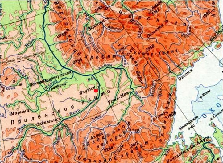
The Republic of SAKHA (Yakutia)
The Shestakovka river catchment basin, located at the border of the Central Yakut plain and the Prilensky plateau, is an object of research in Yakutia.
Scale 1:8 500 000
Shestakovka River
The area of the Shestakovka river basin is 170 km sq, the river is located 20 km South of the city of Yakutsk and is typical of the vast territory of the Central Yakutsk plain. Permafrost rocks with an average annual temperature of -0.5…-3 degrees and a power of 150-500 m have a continuous widespread. The seasonally thawed layer in the sand deposits can reach several meters. The through taliks are confined to the beds of large rivers and lakes. On watershed surfaces meet the supra permafrost taliks. The hydrological post of the Shestakovka river is the village of Kamyrdagystakh in the Roshydromet network, which has been operating continuously since 1951 to the present day. The nearest meteorological stations Yakutsk (beginning of observations in 1834) and Pokrovsk (beginning of observations in 1959) are located at a distance of 20 and 50 km, respectively. Observations began at the Chabydinsky landfill Of the Institute of permafrost SB RAS in the Shestakovka river basin in 1977. For the first time in the harsh climate and continuous cryolithzone of Central Yakutia, non-freezing supra permafrost aquifrost talik were found here, confined to gentle slopes that are covered with dead wood and bearberry pines. A detailed study of the water-heat regime and water balance of sandy grounds in the zone of distribution of the supra-permafrost talik and beyond was carried out at the landfill.
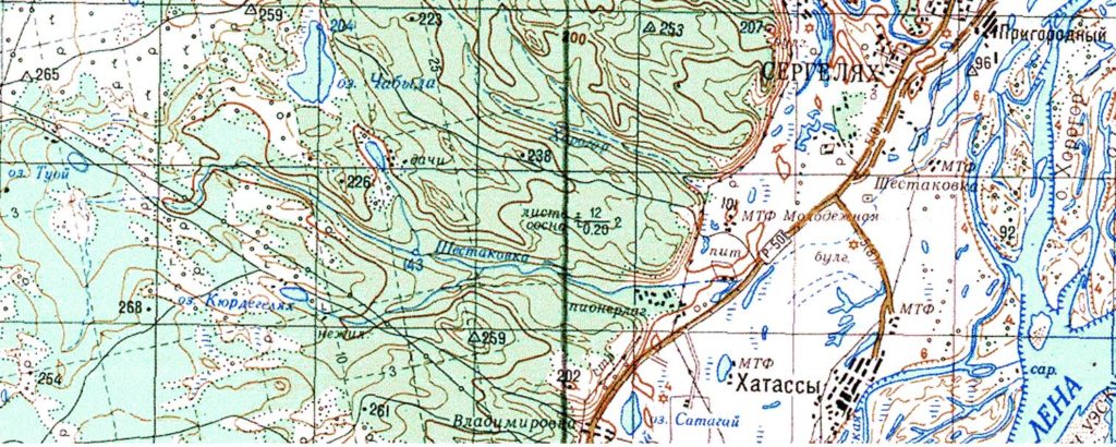
Shestakovka river basin
The territory of Central Yakutia is characterized by a sharply continental climate with severe long winters and short hot summers. In Central Yakutia, one of the highest trends of increasing the average annual air temperature (up to 0.08 ° C / year) has been observed over the past 30 Years. The main contribution to the increase in average annual temperature is made by abnormally warm winters. The average long-term precipitation per year at the Yakutsk weather station for 1951-2014 is 239 mm. The Average daily maximum precipitation is 21 mm. in Yakutsk, more than 35 mm of precipitation falls per day once every 10 years. The highest maximum daily precipitation was observed on July 17, 1951 and amounted to 42 mm. The Average number of days per year with precipitation of more than 5 mm per day is 10, more than 10 mm is 4, and more than 20 mm is 1 day. Snow cover is established in early October, and comes off at the end of April-the first half of may. The average date of the beginning of snow cover destruction is April 30, and the latest date is may 16 (according to the Yakutsk weather station). The probability of snow cover destruction later than may 7 is 10%, and later than may 11 is 5%. The highest decadal height of snow cover in the spring is 37 cm, every 20 years it exceeds 44 cm. Water reserves in the snow at the beginning of melting range from 55-60 mm, with a snow density of 0.16-0.18 g/cm3. In some years, the value of moisture reserves may exceed 70-75 mm. Later snow melting occurs, as a rule, within a short period of time – 2-3 days, which leads to the formation of a powerful wave of meltwater. On dry Sands, these waters penetrate deep into the massif, increasing its humidity, and create conditions for rapid and intensive warming of the soil, which increases during the passage of intense rains in early summer.
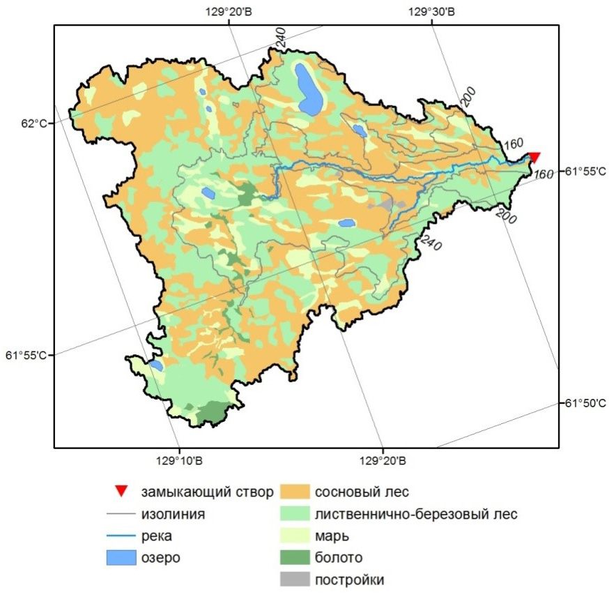
The drainage basin of the Shestakovka river is located within the erosion-denudation slope of the ancient accumulative plain with absolute marks of 100-300 m. The territory of the basin is characterized by hilly-uvalistym relief, there are numerous small river valley, small brooks, elongated erosion depressions with lakes or wetlands. The main type of underlying surface of the Shestakovka river basin is larch-birch forests that grow in decays, subsidence and on flat surfaces. Pine forests occupy mainly slopes and watersheds. Marsh and wetlands are developed along streams and lakes. On the slopes, the Sands are represented by fine and medium-grained fractions, on the watersheds in the upper horizons are developed by sandy loams and loams, below-Sands; on the bottoms of the valleys of streams and decays, waterlogged Sands are covered with organogenic deposits (peat) with a capacity of up to 1 m.
The capacity of permafrost within the river basin reaches 400-500 m. The Temperature in the layer of zero annual amplitudes ranges from 0 to minus 2-3°C and below, depending on the moisture content of the surface and conditions run-off. A wide range of ground temperature fluctuations corresponds to the landscape diversity of the area. The warmest grount are confined to areas of gentle slopes, where the average annual temperature at the bottom of the layer of zero annual heat turns is within the range of -0.2 -1.0 °C. On steep wooded slopes, its values fall to -2.2°C, and the lowest average annual temperatures are recorded in the shallow-valley type of terrain – (-5.1) °C. The depth of seasonal thawing varies from 0.6-0.7 m in wetlands, and on dry areas of slopes up to 2.5-3.0 m. The Greatest interannual changes in temperature and depth of grounts thawing are typical for facies of the bottoms of stream valleys and hollow run-off, and the smallest – for complexes of flat sandy slopes.
The hydrological post of the Shestakovka river is the village of Kamyrdagystakh in the Roshydromet network, which has been operating continuously since 1951 to the present day. The nearest meteorological stations Yakutsk (beginning of observations in 1834) and Pokrovsk (beginning of observations in 1959) are located at a distance of 20 and 50 km, respectively. on the territory of the Shestakovka river basin, observations were started at the Chabydinsky polygon Of the Institute of permafrost studies P. I. Melnikova SB RAS in 1977. The observation range «Chabyda» covered part of the gentle sandy slope of the South-Western exposure with a steepness of 5-7° in the about the watershed part and up to 1-2° near the depression is located lake Small Chabyda. On the slope of a pine forest with undergrowth and crown closeness of 0.2-0.3 is developed. A detailed study of the water-thermal regime of sandy grount was carried out at the Chabydinsky polygon in the zone of distribution of the supra-permafrost talik and beyond. A detailed study of the water-thermal regime of sandy grount was carried out at the Chabydinsky polygon in the zone of distribution of the supra-permafrost talik and beyond. The study was conducted at the water balance site by the team of the cryolithozone groundwater laboratory (Boytsov, 1985; Boytsov and Lebedev, 1989; Boytsov, 2002) and the heat balance group (Scriabin et al., 1998, Varlamov et al., 2002). The main types of work were hydro-regime and temperature observations in wells, studies at the water balance site, where the process of formation of surface and underground runoff, the grount moisture regime was studied, the amount of evaporation and the amount of atmospheric precipitation was determined. Temperature observations were conducted mainly for three wells: Nos. 51, 38 and 15, located, respectively, in the zone of water recharge, transit and fault of underground water of the supra-permafrost talik.
The supra-permafrost taliks of the radiation-thermal type and filtration class identified on dry turf-covered areas weakly dissected terrain composed of uniform sand with a predominance in their composition fractions of 0.20-0.25 mm. In the zone of an elongated depression on a section 5 km long below lake Malaya Chabyda, four talikas were found with an area of from units to several tens of thousands of square meters and an aquifer capacity of up to 3-4 m in the spring and winter period. The largest talik is located on the slope of the lake basin and has the following parameters: length 500, average width 120, maximum thickness 4 m, area 58 thousand m2. Static reserves of underground water in the water-critical period are estimated at 15 thousand meters , and in the autumn, before the beginning freezing, 40 or more thousand m3. The volume of underground runoff is equal to 5-6 thousand m3 of water per year or 35-40 mm of layer. The Chabydinsky test site of the IMZ SB RAS was organized at this talik, where long-term regime and water-balance observations were carried out since 1977.
The average grount porosity of the zone aeraction on the Chabydinsky polygon the range is 33-35 %. The rock filtration coefficient is in the range of 5.7-8.1 m/day. The soil on the site is sod-forest, slightly podzolic, sandy. The upper horizon consists of a forest floor with a capacity of 1-3 cm. Below this horizon, at a depth of 20-25 cm, lies a peat-sand layer with a dense network of small roots. The soil is underlain by quartz-feldspar Sands with grains with a diameter of 0.25 mm mainly. The density of the skeleton varies from 1200-1500 kg/m3 at a depth of 0.1-0.2 m to 1750 kg/m3 at the bottom of the aeration zone. The «constants» of humidity for the Chabydinsky Sands have the following values (in volume percentages): total moisture capacity (PV) – 29-31 %; total ice content (PL) – 27-28 %.
Observations on the Chabydinsky polygon was partially restored in 2015 and started surveillance on the site of the Upper Shestakovka. Measurements of ground water level in talik and ground temperature at various depths in pine and larch forests are carried out. Snow-measuring surveys are conducted before the beginning of snowmelt in various landscapes of the catchment area. During the runoff period (April-October), regular measurements of water flow in two sections of the Shestakovka river are made, basic hydrochemical parameters are determined, and samples are taken from various reservoirs of surface and underground water to analyze the chemical and isotopic composition. Geophysical profiling and drilling operations are performed to identify the geometry and dynamics of aquifers.
In 2015-2018, more than 200 flows were measured in the Shestakovka river basin in two closing wells, 8 wells with a depth of 4 to 20 m were drilled, more than 15 km of geophysical profiles were passed in areas of possible talik distribution, and more than 1000 samples were selected for analysis of the chemical and isotopic composition of water. The water level in the river, lakes, underground waters of Taliks, ground temperature and humidity, and meteorological elements were set to automatic measurement. Performed snow survey, landscape descriptions, etc.